|
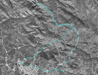
Reminding the traffic of wagons and stables by ways that took us told hydraulic mills, to lurias to avoid the riverbed of the rivers, or just to avoid people going and coming from some territories to others, it has been created a route that still exists in the memory of many Hinojal neighbors: the Rodetes way. In the church we take the exit of the tour and connect it with the way of the Rodetes close to the municipal cemetery, to go among the groves of oaks full of pastures at the shores of the Tagus, concretely of a subsidiary creek, the Fresno creek. Nevertheless, most of the loss of these historical routes makes us get into the Boyal Pasture, well known as Cumbres Gordas. The grove of oaks has turned to be the most important factor of the route.
In addition, the itinerary allows us to reach the Hinojal´s most recondite history, as you must stop in Piedraescrita, situated in the Huerta de la Laguna, or in the Hornos Tejeros. Finally we will cross the remains of an archaeological deposit, Los Castillejos, aborigen people who may be the predecessor of Hinojal. The route will allow us to go through the streets looking for samples of popular architecture, which are disappearing. Then, we will reach the ruinous hermitage of San Juan, where the belfry seems to fall down.
|